
Sheet VI.5.20 of the Town Plan of Glasgow showing the Western Infirmary in 1896.
By the middle of the 19th century the College on the High Street (soon to be known as the University of Glasgow) found itself in an untenable position. As John R. Kellet describes in his 1969 work on the Impact of Railways on Victorian Cities (p. 218):-
By the 1840’s the area around the College had become appallingly decayed and overcrowded. The evening law classes had been abandoned because of the nightly pandemonium of screams and policemen’s rattles, and the inexpediency of bringing young men through the parade of women of the town in front of the college entrance. The adjacent area, in which the students were to find lodgings, included the notorious Vennel and Havanna slums, inhabited by rag dealers, thieves, prostitutes and receivers of stolen goods.
In order to address this unsatisfactory situation, a plan was hatched involving the College, the Treasury and the Glasgow, Airdrie and Monklands Junction railway company (GAMJ) to exchange the High Street campus for a new site, and to subsequently build a commercial goods station at the High Street address. As part of this plan, a sixty acre site at Gilmorehill was purchased from Sir Archibald Bogle (1801-1858) in 1845 for £12,000 by a land company, the Glasgow Western Cemetery Company, acting for the GAMJ. Despite the best efforts of all concerned this plan fell through in 1846 due to various delays and the complications caused by a three-cornered negotiation.
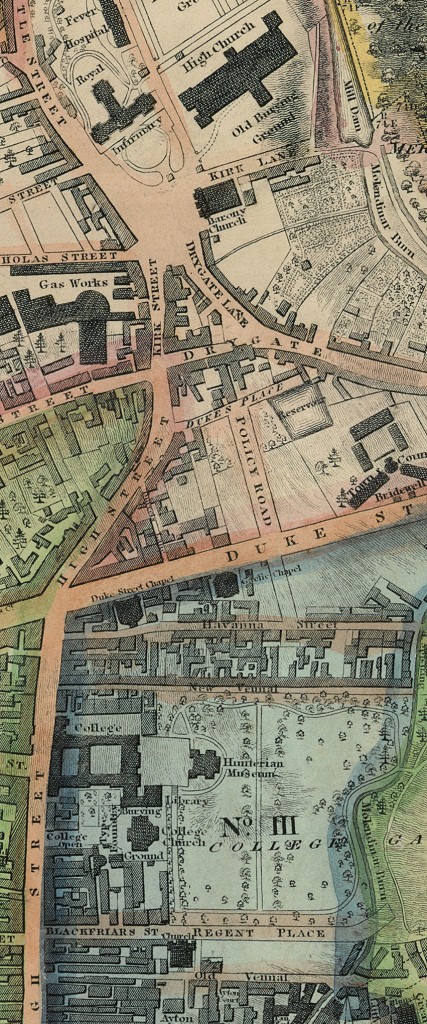
The Royal Infirmary, the Old College and the Vennal and Havanna slums, 1828
One of the many complications was a product of the growing significance of the Medical School of the College. The Glasgow Royal Infirmary had, since its foundation in 1794, provided teaching facilities for the Medical School of the College which matched anything available in Scotland. In large part due to the proximity of the College to the Royal Infirmary, the Medical School grew in size and reputation throughout the 19th century. Consequently, any move to the remote fringes of Glasgow would be problematic for the continued teaching of medicine in the College. A new hospital would have to be factored in to any move to the western edges of the city. A ‘West of Glasgow Hospital’ of some kind…
With no deal taking place, the land company found itself in possession of 60 acres of real estate and with no replacement buyer. Several design competitions were held inviting architects to submit proposals to utilise the land, but ultimately the Gilmorehill Estate lay idle during this period in the care of the now renamed Gilmorehill Company.
It wasn’t until the 1860s that the drive for a move recovered sufficient momentum to be revisited, this time with the City of Glasgow Union Railway Company as the party eager to obtain the prime central location of the University grounds.
Several years of fund-raising by the University ensued, including several petitions to Parliament for financial assistance. After much wrangling everything was eventually in place: approval for the deal was given in the form of the City of Glasgow Union Railway Act, 1864 c. cclxxxvi; the Union Railway Company’s offer of £100,000 in instalments to purchase the High Street site was accepted; and the University finally acquired 43 acres of the Gilmorehill site for £65,000.
The College received the enlarged and picturesque campus it craved, the railway company finally acquired a location for its central goods depot, and the land company pocketed a handsome profit for very little effort. It was a business transaction where all parties could consider themselves winners.
The faculty and students of the University completed their move in 1870 and in 1871 the first foundation stone of the new hospital was laid. By the time the Western Infirmary opened its doors in 1874, all of the Chairs of the College of Medicine had transferred there. In its opening year 235 operations were completed, and in the following three years an average of 153 of its 190 beds were occupied.
Recognising the importance of the hospital to the rapidly growing population of the west of Glasgow, the University entered into an agreement with the then Health Authority of Glasgow in 1878 to transfer this portion of its land for use as a medical facility servicing the west of the city. This became the site of the Western Infirmary as we know it. As part of the agreement, the University retained the option to re-acquire the site should it ever cease to be used for healthcare.
This came to pass over a century later, as a result of the development of the new Queen Elizabeth University Hospital and the subsequent relocation of services. The University was able to finalise purchase of the land in July 2013, as the site would not fulfil a healthcare role in the future. You can read about this process and the plans for development of the site here. The Western Infirmary closed completely on 6 December 2015 after nearly a century and a half of service.
There are several additional points of interest in this map. We can see one of the larger Tram depots in the city to the south of the sheet. The extensive Glasgow tram system ran from 1872 to 1962, and was at the time of its closure the last operational tram transport system in the UK.
The Glasgow Subway system is the third oldest in Europe. Opening in 1896, only London and Budapest were in operation earlier. Partick East station (now Kelvinhall) is shown in this sheet. It took five years to complete the familiar inner and outer circles.
Queen Street to the south of this sheet has since been renamed Thurso Street and is home to the Archives of the University. Archive Services is the central place of deposit for the records created and accumulated by the University since its foundation in 1451.
The zoomable version of this map can be viewed by clicking the image above or by clicking here. You can toggle full page view by clicking the far right icon in the toolbar.
If you have any questions about this map, or any other maps held by the University Library, feel free to contact the Maps, Official Publications and Statistics Unit.
Many thanks to Archive Services for their assistance in clearing up some confusion over contradictory accounts of this period.
Other entries in the series:
Pollockshields Town Houses and Villas
Queen Street Station and George Square
In creating this ‘broad strokes’ account of the move of the University, and the origins of the Western Infirmary, the following sources have been invaluable:-
Kellett, John, 1969. Impact of Railways on Victorian Cities. London : Routledge & K. Paul.
Categories: Library, Official Publications
Related Articles
-
 Miners, AI, and wind turbines : New Official Publications 07.05.24
-
 Fiscal Drag, Vaping, and the United Kingdom – New Official Publications 17.04.24
-
LGBTIQ equality, the Antarctic, and vapes: New Official Publications 02.04.24
-
Conversion Practices, the Sarah Everard Inquiry, and A&E wait times: New Official Publications 05.03.24

Leave a comment